Showing posts with label proposals. Show all posts

27 May 2020

London's Unbuilt Monorail

Monorail systems once looked like the most futuristic form of public transport. Today, their reputation isn't quite as bright, but in the 1960s there were plans to bring an elaborate monorail network to the centre of London.

London's Unbuilt Monorail (click to enlarge)

The scheme, proposed by architect Brian Waters and endorsed by the Conservative Opposition at the Greater London Council, would have involved four loops of track elevated above London, alleviating congestion on the streets below.

The map above imagines how the network might appear in the style of a modern-day Tube map. It's worth emphasising that although we know the routes that the four loops would have taken, the exact number and position of the stations is largely speculation. Given that the monorail network was intended as a substitute for the bus network, it's likely that the stops would have been spaced more closely together than stations on the London Underground. This means that the map probably underestimates the number of stations on each loop.

For more information about the proposals, check out this article by IanVisits, or grab a copy of the original proposals.

30 June 2019

Cutting the Cost of Crossrail 2

Six months after its planned opening date, we still aren't sure exactly when Crossrail 1 will begin carrying passengers under central London. The fate of its sequel, Crossrail 2, hangs in the balance, although it has recently won some enthusiasm from the UK's probable next Prime Minister.

Crossrail 2 would be a new underground rail connection between the southwest and the northeast of London, following much of the same design philosophy as the east-west Crossrail 1. In 2015 a consultation was launched describing a proposed route, and in 2018 an Independent Affordability Review was established with the stated aim of guaranteeing the project's value for money.

Crossrail 2 route map, as of 2015 consultation
Even though the Affordability Review was supposed to conclude in summer 2018, there's been no word yet regarding its findings. In the meantime, discussion of the project has continued on less official channels.

In May 2019, the TaxPayers' Alliance published a report suggesting ways in which the cost of the scheme could be brought down and proposing alternative schemes which (they argue) could provide better value for money. In this post, I'll map out some of their ideas.

I should emphasise that, having no background whatsoever in transport planning or civil engineering, I'm not in a position to speak with any authority on the merits of these proposals. My motivation, first and foremost, is that producing colourful maps is fun. This post does offer an opportunity to explore the official Crossrail 2 plans in more detail, which I hope is useful regardless of how seriously the alternative suggestions should be taken.

Current Crossrail 2 proposals

Crossrail 2's core section consists of a new pair of rail tunnels between Wimbledon and New Southgate. In this section Crossrail 2 would serve many stations providing interchanges with other lines, including Tottenham Court Road and Euston St Pancras.

In the southwest, Crossrail 2 services would run on National Rail track and serve destinations in London's suburbs. In the northeast, there would be a branch from Dalston to Tottenham Hale and Broxbourne using existing track on the West Anglia Main Line.
2040 Tube Map
2040 Tube Map putting Crossrail 2 in context
The scheme is intended to serve many different goals:
  • Taking suburban services in South West London off the tracks into Waterloo (replacing them with Crossrail 2 services) frees up capacity for more longer-distance services to run to Waterloo
  • Building extra tracks on the West Anglia Main Line north of Tottenham Hale allows more National Rail services to run to Liverpool Street and Stratford
  • A station at Balham or Tooting Broadway helps relieve pressure on the Northern line, in particular by scooping up passengers who would otherwise have changed onto the Victoria line at Stockwell
  • A station at Euston helps better disperse passengers arriving from HS2
  • Improving transport access for outer London opens up new housing opportunities (which, as London Reconnections writes, is very often overlooked)
Any description of Crossrail 2 needs some strong caveats about the likely extent to which the plan will change. The proposal has already evolved considerably: an ancestor of the scheme (still connecting Wimbledon and Dalston) is among a set of new lines proposed in 1946. For a long time the scheme was known as the Chelsea-Hackney line and could have taken over the Wimbledon branch of the District line and one of the eastern branches of the Central line.

1946 proposal which would gradually evolve into Crossrail 2
Probably the only certainty about Crossrail 2 is that it won't look exactly like the proposal in the 2015 consultation. Among the aspects that would only be finalised at a very late stage is the name. Like Crossrail 1, which will open with services branded as the Elizabeth line, Crossrail 2 will almost definitely adopt a new name when trains start to run.

TPA's alternative

The TPA report suggests a number of revisions to the scheme. The stations providing few interchange opportunities (Chelsea) or requiring circuitous diversions (Balham) would be cut. The central section would follow a different route, avoiding Euston St Pancras in favour of destinations closer to the City of London, with three alternatives put forward. The northwestern branch would be dropped entirely, potentially replaced with a surface-level branch to Gordon Hill.

TPA proposal for Crossrail 2
The report also suggests some projects which could replace Crossrail 2 altogether. Before looking at those, let's examine (with the help of some colourful maps) the alternative route suggestions in the central section, followed by the TPA's suggested way of cutting the cost of Wimbledon station.

Altering the route

As currently proposed Crossrail 2 would serve three central stations: Victoria, Tottenham Court Road and Euston St Pancras. The Crossrail 1 station at Tottenham Court Road has already been "future-proofed" in anticipation of a pair of north-south Crossrail platforms, which can be seen in this video from Geoff Marshall (at about 3:45).
Sketch of Crossrail 2 at Tottenham Court Road, from 2015 consultation
The TPA report puts forward three alternative routes in this central section. One alternative keeps the Tottenham Court Road station but replaces Euston St Pancras with a new station at Clerkenwell (including new platforms on the Circle line, between King's Cross St Pancras and Farringdon). Another alternative would put a Crossrail 2 station between Chancery Lane and Farringdon. The third alternative serves City Thameslink as well as Crossrail 1's Moorgate / Liverpool Street complex.

There could be some headaches for tube mappers. The current tube map overstates the distance between Farringdon and Chancery Lane (by putting Farringdon much closer to King's Cross St Pancras). On a tube map where Crossrail 2 serves Farringdon / Chancery Lane, this distortion would have to be addressed. 
Good luck squeezing in the station name labels!
That said, there is still a long way between the station platforms at Chancery lane and at Farringdon (as Franklin Jarrier's excellent CartoMetro map indicates), meaning that a Crossrail 2 station there could involve some very lengthy interchanges.

Platform use at Wimbledon

Wimbledon is one of the most complex stations in Outer London, with four District line platforms, five National Rail platforms and two Tramlink platforms. At platforms 6 and 7, trains usually run through the station without stopping, and those two platforms are generally closed to passengers.
Current platform layout at Wimbledon
Crossrail 2 would make the station even more complex. Under the 2015 consultation proposals, the existing Tramlink platforms would be relocated outside the station, and four new Crossrail 2 platforms would be built (at a lower level than the existing platforms). Platforms 10 and 13 would be used for "through" trains to and from South West London, while platforms 11 and 12 would be used for trains starting and finishing at Wimbledon (very similar to plans for Crossrail 1 at Old Oak Common).
Wimbledon after Crossrail 2 (2015 consultation proposal, with some further information from here)
The TPA report suggests instead putting the "fast" South Western tracks in tunnels under the station, so that platforms 6 and 7 can be used for Crossrail 2. This would save having to build additional platforms on the site of Wimbledon's Centre Court shopping centre.
Wimbledon after Crossrail 2 (TPA proposal)

Something completely different

The TPA report ends with suggestions for transport schemes which it argues could meet some of Crossrail 2's objectives at a lower cost. One of these is an extension of the DLR from its terminus at Bank to Euston and St Pancras.
DLR extension to Euston and St Pancras
Three more of the suggestions are mapped below:
Inner South London metro
Connection from Herne Hill to Fenchurch Street
North and East London express metro


Conclusions

A decision on next steps for Crossrail 2 is planned to form part of the 2019 Spending Review. Given that policymakers in the UK might have (*cough*) a lot on their plate in autumn 2019, it's possible that the decision could be delayed. The scheme's high price tag, the delays and cost overruns befalling Crossrail 1 and complaints of disproportionate infrastructure investment in London pile on pressure to delay Crossrail 2 or kill the project off entirely.

But as we've seen, the principles behind the Crossrail 2 proposals have been around for decades. The transport and housing issues which the project is intended to address will still need answers. For as long as that's the case, the idea of Crossrail 2 won't go away.

23 January 2019

Extending the Docklands Light Railway

The Docklands light Railway (DLR, for short) has been one of London's major transport success stories. Opening with just 15 stations in 1987, the network currently serves 45 stations in East and Central London. Unlike buses, trams, the London Overground or TfL Rail, the DLR yields more for TfL in passenger revenue than it costs to operate. The system played a pivotal role in bringing regeneration to the London Docklands and transforming Canary Wharf into the one of the world's most important financial centres.

In some ways the DLR has been a victim of its own success. With passenger numbers exceeding expectations, many of the past and planned improvements to the DLR have focused on increasing capacity: in particular, by lengthening trains and station platforms and by improving junctions so that services can run more frequently.

But it's also intriguing to look at which new destinations the Docklands Light Railway might serve. The map below depicts the current DLR network, together with a number of extension proposals, past and present:
Docklands Light Railway network, with proposed extensions

Sources and caveats

All of the extensions on the map come from official sources: most come from the DLR Horizon 2020 Study (from July 2005) and the "Planning for the Future of the DLR" map (from May 2011, shown below).
Original map can be found archived here, with its accompanying article here
However, it's worth stressing from the outset that official consideration of DLR extensions has more recently become much narrower. In the Mayor's Transport Strategy from March 2018, discussion of the DLR focuses specifically the proposed extension from Gallions Reach to Thamesmead.
Detail from Figure 31 of the Mayor's 2018 Transport Strategy, with DLR extension in turquoise
The DLR extensions map contains some annotations which explain a little bit of the background and trivia behind the proposals. Below are descriptions of a couple of the proposals in geekier detail.

Wood Wharf extension

The proposal to extend the DLR to Wood Wharf came about because of a capacity constraint in the original DLR. North of West India Quay, the Bank and Stratford branches met each other at a flat crossing. Trains running north from West India Quay to Stratford had to cross the path of trains running south from Bank to West India Quay, limiting the frequency at which trains could run.
Very simplified illustration of track north of West India Quay
Grey track was rarely used for passenger service
The Horizon 2020 report investigated the possibility of sending Stratford trains along a new track which avoided Canary Wharf (and the difficult crossing) entirely. The new track would meet the existing track south of Wood Wharf at a more efficient junction.
Stations around Canary Wharf, including the proposal for Wood Wharf
Base image: Google Earth
The Wood Wharf proposal had drawbacks. In particular, travellers from Stratford would no longer have direct trains to Poplar (providing interchange opportunities with other DLR routes) or the stations on Canary Wharf.

In 2009, a different solution was put in place. New track was built so that trains from Bank could run directly from Westferry to Canary Wharf and avoid crossing the path of trains to Stratford.
Very simplified diagram of new track layout
The new track to Canary Wharf passes underneath the tracks to and from Poplar
This improves the possible service frequency, but means that trains from Bank can't stop at West India Quay. This unusual arrangement isn't currently depicted on the standard Tube map, but is shown on the DLR map:
Detail from current official DLR map
With the new track in place, there is much less need for the Wood Wharf extension. There will still be new development at Wood Wharf (with completion currently planned for 2023), but without a new DLR station.

Western extensions

Tunnelling west of Bank would be extremely expensive, and a lot of attention has been given to cunning re-use of existing infrastructure in order to cut costs. The Horizon 2020 report considers the  re-use of the Farringdon City Sidings, built alongside the adjacent London Underground track and once used to carry Thameslink trains from Farringdon to Moorgate.

The plan now is to put the tracks to a different use, as a place to stable London Underground trains overnight. This means the tracks are very unlikely to see use as part of a DLR extension.
Detail from a 1999 map of London's rail services (saved at the London Tube Map Archive),
showing National Rail services from Farringdon to Moorgate
A DLR extension to St Pancras and Victoria (listed as "Option A" on the main map above) would be particularly ambitious. As noted at London Reconnections, the portion from Euston to St Pancras would follow the same route as that proposed for an automated people mover (APM) between Euston and St Pancras. The APM would quicken the connection between HS1 (at St Pancras) and HS2 (at Euston), and a DLR extension would play a very similar role.
Artist's impression of an APM station at St Pancras, from Arup's report to HS2
Crossrail 2 would also create a connection between Euston and St Pancras with a new station underground. Putting this new station on the Tube map as an interchange with Euston and King's Cross St Pancras is a very tough task, and my own attempt (for the 2040 Tube Map) could definitely be improved upon. Adding DLR stations to Euston and St Pancras, in addition to the Crossrail 2 link, would be an even tougher challenge.
A monstrous interchange  but it could be even worse

27 September 2018

Alternate Universe Tube Map

This post was last updated on 24 May 2022


After having a go at showing what the Tube map might look like in 2040, I wanted to try and present a map from an alternate history, where the Tube looks faintly familiar but still strikingly different.

This is what I ended up with:
Alternate Universe Tube Map
There's a lot that's different. The executive summary:
  • The map is based on proposals put forward in 1946, which you can read online here, and read a little more about here
  • The report's authors were particularly concerned about overcrowding at London Bridge station and the space taken up by railway viaducts on the South Bank
  • Their solution was radical: demolish the overground stations at London Bridge, Charing Cross and Cannon Street altogether
  • Suburban trains originally travelling to London Bridge would be sent into one of five new tunnels running across London (in the style of Crossrail and Crossrail 2), taking over suburban services on the other side
  • Two further Crossrail-style lines and one new Tube-style line were put forward to relieve congestion elsewhere on the network
  • A few existing Tube lines would get extensions and tweaks, especially the Northern line
The map itself contains annotations in grey which explain a little about what's going on. What follows below will go into geekier detail, following the same structure as the bullet points above.

Background

So, it's January 1946. The Victoria line, Jubilee line, Overground, DLR and Emirates Air Line are nowhere to be seen. The Metropolitan and District lines share the same identity on the Tube map and serve quirky places like Aylesbury, New Cross and South Acton. Although the construction of underground railways previously had been something of a free-for-all, the London County Council and (as it was called until April 1946) the Ministry for War Transport were now taking a more active role in overseeing the development of London's transport.

In 1943, the County of London Plan was published, with its own section on rail transport. A particular concern was the number of railway viaducts around the South Bank and their effect on development around places like Southwark Cathedral (shown below).
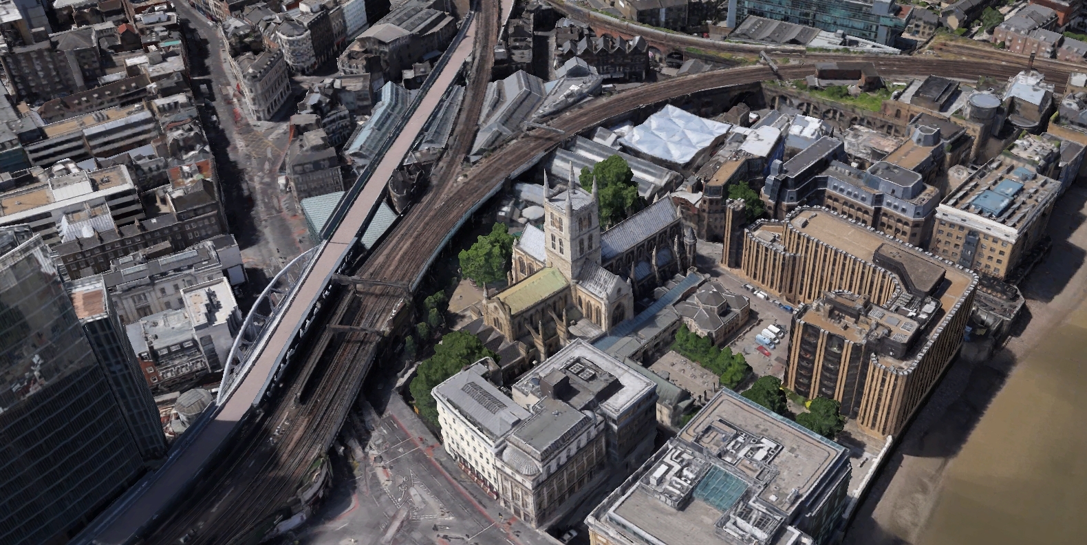
Southwark Cathedral and the surrounding railway viaducts today
Image: Google Earth
The "Railway (London Plan) Committee" was set up to investigate the proposals in the County of London Plan and make their own comments and suggestions. The Committee's response was set out in the 1946 Report to the Minister for War Transport, which from now on I'll just call "the 1946 report". It is this report which forms the basis of the alternate-universe Tube map: the map depicts a world where all the proposals from the 1946 report came to fruition.

Why use the 1946 proposals to construct an alternate-universe Tube map when other proposals (including the 1943 County of London Plan) could have worked just as well?

First, the 1946 report was particularly ambitious, allowing this alternate-universe Tube map to feature eight fictional lines. Most proposals made before and since have been far more cautious, often suggesting no more than one new line at a time.

Second, the 1946 report contains suggestions which closely resemble proposals which actually did come to fruition in real life. Most strikingly, we see an underground line linking Victoria and King's Cross (like the real-life Victoria line) and a line linking Wimbledon and Dalston (like the current proposals for Crossrail 2).

The third reason is more practical: the 1946 report's availability online (including its full text in searchable form at archive.org) made it particularly easy to adapt as a Tube map.

London Bridge problem, Crossrail solution

The Railway Committee shared the concerns in the County of London Plan about the railway viaducts around the South Bank. They were also worried about the heavy passenger traffic arriving at London Bridge station: they reported that 60,000 passengers arrived at London Bridge during the morning peak hours, more than any other London terminal except Liverpool Street.

The County of London Plan proposed that the viaducts through London Bridge station to Cannon Street and Charing Cross be demolished and replaced by a deep-level tube line. Suburban rail services to London Bridge would run in a loop: entering a tunnel south of London Bridge station, trains would then travel to London Bridge underground station followed by Waterloo Junction, Charing Cross, Blackfriars and Cannon Street (or those four stations in reverse order) before returning to London Bridge and rejoining the surface lines again.
Loop line proposed in the 1943 County of London Plan
The 1946 report expressed concern about running lines in a loop like this. The frequency of service in the loop would be severely constrained, since clockwise and anticlockwise services would share the same tunnel through London Bridge. If (say) 24 trains per hour ran northwest through London Bridge, only 12 could run clockwise and 12 anticlockwise.

Furthermore, the junction north of London Bridge would require careful timetabling so that clockwise and anticlockwise trains don't have to wait for each other when merging back onto the line through London Bridge. Disruption to one service could have significant knock-on effects by forcing trains to wait longer at the junction.

The Committee's solution followed the same philosophy underlying Crossrail and Crossrail 2: rather than run suburban London Bridge services in a loop and send them back where they came from, run them in tunnels underground across London and have them link up with suburban services on the other side. Five new cross-London lines were proposed, each one adapting a different portion of the suburban railway fanning out from London Bridge.

According to the 1946 report, the cross-London tunnels would carry up to 25 trains per hour, have tunnels 5.1 metres in diameter (large enough to carry full-size trains) and have platforms 198 metres long. Compare this with the real-life Crossrail, which opened in May 2022: tunnels are 6.2 metres in diameter, platforms are 240 metres long and the route will ultimately carry 24 trains per hour through its core in each direction.

Tower Bridge Road

Although London Bridge would no longer be the terminus for suburban services, there would still need to be a terminus for long-distance regional services and an interchange between the different cross-London lines. The London Bridge site was considered unsuitable for this, so the 1946 report proposed build a new interchange hub from scratch, further east on Tower Bridge Road.
Proposed site of Tower Bridge Road station as it appears today
Image: Google Earth
Tower Bridge Road wouldn't be the final terminus for long-distance services: they would travel by viaduct a little further west to Waterloo Junction, which today is known as Waterloo East. The viaducts connecting Tower Bridge Road to Waterloo Junction would be built from scratch along a new more direct route.

Although Waterloo Junction would have no underground connections of its own, the Railway Committee saw it as serving an important role as an interchange with the main Waterloo station and as a destination for passengers seeking to continue their journey by foot, bus or taxi.

Lines in detail

Before diving into more detail about the individual lines, it's worth noting that the 1946 report didn't assign them names or colours. I uncreatively chose portmanteau names in the style of the Bakerloo line, which I hope are at least more informative than "District" and less of a mouthful than "Waterloo & City".

The report doesn't go into much detail about service patterns on the new lines or how services on surrounding above-ground routes might change. This means the positioning of rail interchange icons involved a lot of speculation. Take these with a pinch of salt!

Tower Bridge Road lines

Tower Bridge Road lines
From top to bottom: Bankbone, Cricklefleet, Dartling, Finsmoor and Leatherwat
The five Tower Bridge Road lines would, between them, take over all the suburban services formerly bound for London Bridge, Charing Cross and Cannon Street.

Many portions of the Tower Bridge Road lines are familiar, having made it on to the Tube map in other forms. The northern portion of the Leatherwat line from Watford Junction to Euston is currently part of the Overground. The Dartling line's western section between Maidenhead and Paddington is now part of the Elizabeth line. Although the Bankbone branch from Elmers End to Addiscombe no longer exists as a heavy rail line, part of the route was adapted for the Croydon Tramlink.

The Finsmoor line was proposed to incorporate the Northern City Line from Finsbury Park to Moorgate, which was once a self-contained part of the Northern line but presently (in real life) falls under Great Northern. Some have suggested that this line should be now be devolved to TfL and form part of the London Overground. The Finsmoor line would also take over the railway from Finsbury Park to Alexandra Palace, which exists today only as the Parkland Walk.

Viking line

Viking line
The Viking line was actually proposed in the 1946 report as two separate lines. Since they share the same route north of Finsbury Park they're combined here for the sake of simplicity. The western (East Croydon) branch and the eastern (Sevenoaks) branch would have separate platforms at Finsbury Park and rejoin the surface lines to Stevenage and Hitchin between Finsbury Park and Harringay.

The East Croydon branch closely resembles the real-life Victoria line: the Viking line and the Victoria line both serve Brixton, Stockwell, Vauxhall, Victoria, Euston, King's Cross St Pancras and Finsbury Park. The Sevenoaks branch shares features in common with real-life Thameslink, but would run underground all the way between Loughborough Junction to Harringay.

Under the 1946 proposals, the tunnels north of Farringdon which today are used for Thameslink would have become part of a new underground route specifically designed for freight. This route would have run from Loughborough Junction to Blackfriars, Holborn and Farringdon before joining these pre-existing tunnels and rejoining the mainline rail system.

Wimbleching line

Wimbleching line
The Wimbleching line was intended to relieve congestion on the South Western Main Line between Raynes Park and Waterloo by diverting suburban trains from Motspur Park through a new underground route. Suburban services to Chingford (in real life, now part of the London Overground) would be absorbed at the other end.

The Wimbleching route very closely resembles the real-life Crossrail 2 proposals. A new underground railway from south-west to north-east London has been seen as a priority for London for a long time, and the 1946 report illustrates just how long.

The southern tunnel portal for the Wimbleching line would be southwest of Raynes Park, an area which in 1946 was a goods depot but is now an industrial estate. Crossrail 2 is more ambitious, with the tunnelled section beginning between Raynes Park and Wimbledon. This would allow Crossrail 2 services to run to Hampton Court and Shepperton as well as Chessington and Epsom.

Golders line

Golders line
The Golders line, uniquely among the lines proposed by the Railway Committee, would have narrower tunnels only able to fit Tube-size trains. To highlight this, this is indicated on the Tube map with a solid line rather than the double or "cased" line used for the other new lines. The line was designed principally to provide relief for the Northern line's northern branches. A proposed alternative in the 1946 report was to double the existing Northern line tunnels between Golders Green and Waterloo.

Northern line

Improved Northern line
Many improvements to the Underground's existing lines were planned or proposed before the Second World War. Most famous of these was the Northern Heights plan: a new Northern line branch would be built to connect Finchley Central to Edgware, and the Edgware branch would be extended to Bushey Heath. The Northern Heights also includes the incorporation of the Northern City line and Alexandra Palace branch into the Northern line, but under the 1946 proposals they would have formed part of the Finsmoor line.

As noted above, either the Golders line or doubling the Northern line between Golders Green and Waterloo would ease crowding on the northern section. On the southern section, the Charing Cross branch would be extended south of Kennington along the same route as the existing Morden branch, rejoining the old Northern line south of Tooting Broadway. The Committee proposed that trains on the Bank branch (using the old track) would terminate at Tooting Broadway, while trains on the Charing Cross branch would continue further south.

Although the 1946 report does not mention it explicitly, it seems likely that the doubling of the Northern line would have made use of the deep-level shelters built under Northern line stations during the Second World War. The doubling of the line would free up capacity for an extension to North Cheam. It seems likely that one of the sets of Northern line tunnels between Kennington and Tooting Broadway would run an "express" service, missing out stations like Oval and Clapham South, but the 1946 report makes no explicit proposals about this.

The section of the Northern line between Morden and Kennington remains today one of the most crowded on the London Underground. Crossrail 2 is intended to relieve some of this crowding with a station at either Tooting Broadway or Balham.

Other lines

It's worth quickly mentioning some of the other lines. In 1946 the Central line's western section ran to Ealing Broadway, with no West Ruislip branch. There were plans to extend the line as far as Denham but in real life the extension was only built as far as West Ruislip. The Central line would reach Ongar in 1949, but in real life services from Ongar usually only went as far as Epping. The Central line service between Epping and Ongar was withdrawn entirely in 1994.

There were plans in the 1930s to extend the Bakerloo line to Walworth and Camberwell. This is depicted in one of the maps accompanying the 1946 report, fainter than the other plans and proposals, but isn't mentioned in the text of the report.

Next steps

The Railway Committee anticipated that all their proposed lines and extensions could be finished within 30 years. So the "alternate universe Tube map" isn't so much an alternate present day as an alternate 1976.

The intriguing (especially geeky) question is how the alternate-universe Tube would have been improved upon in the years between 1976 and the present day. Would the Docklands Light Railway have been built, and would it follow the same routes? Would Heathrow be served in the same way? Would a new line be needed (like the real-life Jubilee line) to better serve the existing line to Stanmore? Would the dedicated freight line have been adapted for passenger service? Which services, if any, would be cut back?

I definitely can't answer any of these questions, but I would emphasise two takeaways from the 1946 proposal and the alternate-universe Tube map.

First, many of the planning problems facing London after the Second World War were strikingly similar to those facing planners today, not least because of the glacial speed at which solutions are put into action. For example, planners are as concerned today as they were in 1946 about congestion on the Northern line and on the surface railway lines approaching Waterloo, and the "Crossrail philosophy" was the proposed solution in 1946 as well as now.

But on the other hand, the planners after the Second World War were not afraid to be bold. Their proposals would have profoundly reshaped London's transport infrastructure, especially south of the river, and given rise to a Tube map very different from the one we know.

10 September 2018

2040 Tube Map

This post was last updated on 24 May 2022

A little while back I had a go at mocking up what the abstract, colourful and geeky Tube map might look in 22 years' time:
2040 Tube Map
2040 Tube Map (click to enlarge)

How did this start?

The map started out primarily as a way of showing how the proposed Crossrail 2 would look on the Tube map. Crossrail 2 would be an underground rail link between Surrey in the south-west and Hertfordshire in the north-east, the more ambitious sequel to Crossrail 1 (which opened in May 2022 as the Elizabeth line, but was still under construction in 2018 when the map was drawn). I'd found two Tube maps featuring Crossrail 2 that had been made previously: Alex Hern's map for New Statesman and Brian Butterworth's 2050 Tube map for UK Free TV.

Putting Crossrail 2 on today's Tube map would be a little strange, since by the time Crossrail 2 opens (if it does; at present it's still just a proposal) there are other ways in which the Tube map will probably have changed. This year Sadiq Khan published a Transport Strategy document outlining the vision for London, so why not add all the proposals to the map in addition to Crossrail 2?

What new features are on the map?

To list them quickly:
  1. Crossrail 1
  2. Crossrail 2
  3. Northern line extension to Nine Elms and Battersea Power Station
  4. Bakerloo line extension to Lewisham, Beckenham Junction and Hayes
  5. DLR and Overground extensions to Thamesmead
  6. New Tramlink from South Wimbledon to Sutton
  7. West London Orbital from Hounslow to West Hampstead and Hendon
  8. Old Oak Common station
  9. Re-routing the Piccadilly line to serve Chiswick Park and Ealing Broadway

What's Crossrail 1, exactly?

Crossrail, which began carrying passengers in May 2022 (with services branded as the Elizabeth line), was four years away from opening when the 2040 Tube map was put together.

Image result for elizabeth line map
Crossrail 1 / Elizabeth line (full size)
The line isn't, technically speaking, a new Tube line, even though much of it runs underground: the trains are as tall and wide as ordinary overground trains and twice the length of Tube trains. The futuristic stations have platforms so long that some Crossrail stations have a different Tube station at each end, which can make some of the interchanges on the Tube map look a little puzzling.

The 2040 map also includes an extension from Abbey Wood to Gravesend, included as a proposal in the Transport Strategy.

What about Crossrail 2?

Much of the design philosophy behind Crossrail 2 is very similar to Crossrail 1: full-size trains would run directly across London underground; the new service would absorb some suburban services which previously ended at big London terminal stations; platforms would be long enough that some stations have a different interchange at each end.

Crossrail 2's route from the 2015 consultation (full size)
Rather than run from east to west, it would run from southwest to northeast, with a tunnelled section between Wimbledon, Tottenham Hale and New Southgate. This tunnelled core wiggles around central London trying to hit as many key interchange points as possible, including the monstrous Euston St Pancras (discussed in this CityMetric article, which includes an earlier version of the 2040 Tube map).

South of Wimbledon, Crossrail 2 would take over some suburban services to Epsom, Chessington, Hampton Court and Shepperton which currently run to Waterloo. Northeast of Tottenham Hale, Crossrail 2 trains would run along the existing route to Broxbourne. In both the southwest and northeast sections there'd be extra track and tinkering with the stations to accommodate the extra Crossrail 2 trains. (If you're feeling especially geeky, there's a diagram showing Crossrail 2's possible service pattern in South West London, but the caveat that it's all quite speculative can't be repeated enough.)

Much about Crossrail 2 is subject to change, and it hasn't (yet) been given an official name or colour. Some people have unofficially suggested calling Crossrail 2 the "Palace line" since it connects Nonsuch Palace, Hampton Court, Buckingham Palace and Alexandra Palace; the name also follows the royal theme set by "Elizabeth line". Many publicity documents (as well as the Transport Strategy) have coloured the line green, but I opted to follow Alex Hern and coloured the line in hot pink, which I reckon goes well with Crossrail 1's lilac.

What are the extensions to the Northern and Bakerloo lines?

The Northern line extension from Kennington to Nine Elms and Battersea Power Station opened in autumn 2021. The 2040 Tube map also depicts the Northern line split into two halves, with the Edgware-Waterloo-Battersea section running completely separately from the Barnet-Bank-Morden section. TfL have been keen on this for a long time, but what's needed first is an upgrade to capacity at Camden Town.

Northern Line extension (full size)
The Bakerloo line extension is first proposed to run from Elephant & Castle to Lewisham via two Old Kent Road stations (which haven't yet been given official names) and New Cross Gate. A further extension of the Bakerloo line could take over suburban services to Hayes and Beckenham Junction.

What's up with Thamesmead?

First, there are plans to extend the London Overground's Gospel Oak to Barking ("Goblin") line to Barking Riverside, planned to finish in 2022. Following this, the DLR and Overground could be extended across the Thames to Thamesmead by bridge.

... and there's a new Tramlink too?

In 2014 there was a consultation on extending the Croydon Tramlink from Morden Road to Sutton, so that (as an alternative to taking the infrequent and unreliable Thameslink service) you could get a tram from Sutton to Wimbledon. That consultation put many alternative routes forward, and the route favoured by the Transport Strategy document is to have the Sutton Tramlink run on a fully-separate route and terminate at South Wimbledon. There would be an interchange between the two Tramlinks at Morden Road.
Croydon and Sutton Tramlinks

... and there's more Overground as well?

As well as the Goblin extension described above, the Transport Strategy includes a proposal for a new Overground line from Hounslow to Hendon and West Hampstead. The cool part of this proposal is that even though the route is new, all the track is already in place, some of it (like the Dudding Hill line between Acton Central and Cricklewood) very lightly used.
West London Orbital

Old Oak Common is on the 2040 map but isn't on the Elizabeth line route map. Why?

Old Oak Common is a station on the High Speed 2 route planned to open in 2026. On the one hand, it will provide an interchange between High Speed 2 on the Elizabeth line; on the other hand, the site could contain stations on up to three Overground routes: the North London Line, the West London Line and the proposed West London Orbital.

Image result for old oak common hs2
Old Oak Common map from Wikimedia Commons
Squeezing such a complex interchange onto the Tube map would ordinarily be quite difficult, but a quirk of the Tube map's layout makes this easier. The Tube map has always exaggerated the distance between Willesden Junction and North/East Acton, leaving a gap where Old Oak Common can be stuck in.

The different Overground stations connecting with Old Oak Common have been given different names: Hythe Road on the line to Shepherd's Bush, Old Oak Common Lane on the line to Willesden Junction and Old Oak Common Victoria Road (along the grey Dudding Hill Line on the map above) on the line to Harlesden. Needless to say, fitting all these names on the map would have been a struggle!

What's going on at Ealing Broadway?

This is a quirky one, pointed out to me by the Good People of the Internet™ when I posted a previous version of the map. The biggest issue with the current arrangement is the track shared between the District and Piccadilly lines at Ealing Common; cutting back the District line from Ealing Broadway and sending the Piccadilly line there instead means that both lines can be more frequent and reliable. (London Reconnections has a great article on this which explains it all much better than I can.)

What happened to the step-free access icons? What about fare zones?

I omitted both of these because their futures are so hard to predict. Step-free access improvements are made regularly and aren't planned as far in advance as new lines and extensions. Right now we don't know what zones the western Crossrail stations will be in; by 2040 the fare zone system could well have been overhauled in its entirety.

Similarly, it's tough to predict what will have happened to the London Overground by 2040. TfL has its eye on the whole of South London's suburban lines, plus the Northern City Line to Moorgate (see this map from the Transport Strategy), but what happens will have a lot to do with politics (again, London Reconnections has a great in-depth article on this).

Where's [proposed new line/station that's not on the map]?

A lot of people have asked why the Croxley Rail Link, which would re-route the Metropolitan line from Croxley to Watford Junction, isn't on this map. It's appeared on future Tube maps before, including TfL's own 2021 Tube map (published in 2013), but at present it looks a lot less likely to happen; in the Transport Strategy it's not mentioned once. Having "is this proposal in the Transport Strategy?" ended up being a useful criterion for what to show: this way there are no "maybe I should throw this in?" grey areas.

What about Thameslink?

When making the map I tried to stay as close as possible to the principles behind the original Tube map; this meant showing the Overground, Tramlink, Emirates Air Line and DLR but not showing rail lines which aren't run by TfL. Many people who saw the map asked whether lines like Thameslink (a train line which runs across London but isn't run by TfL) or new National Rail links around Heathrow Airport ought to be included.

But at the same time others asked whether there was already too much information crammed onto the Tube map, especially when projected forward to 2040. Jonn Elledge at CityMetric asked whether including Overground, the Crossrails and the Tramlinks makes the map too cluttered.

The balance between (on the one hand) providing enough information to usefully assist journey planning and (on the other hand) avoiding information overload is a super tough one. I definitely don't have any easy answers, which is the main reason why, when it came to the criteria for which lines to include on the map, I stuck to the status quo (or at least what was the status quo, until Thameslink joined the official Tube map in 2020).