This post was last updated on 24 May 2022
A little while back I had a go at mocking up what the abstract, colourful and geeky Tube map might look in 22 years' time:
 |
| 2040 Tube Map (click to enlarge) |
How did this start?
The map started out primarily as a way of showing how the proposed Crossrail 2 would look on the Tube map. Crossrail 2 would be an underground rail link between Surrey in the south-west and Hertfordshire in the north-east, the more ambitious sequel to Crossrail 1 (which opened in May 2022 as the Elizabeth line, but was still under construction in 2018 when the map was drawn). I'd found two Tube maps featuring Crossrail 2 that had been made previously: Alex Hern's map for New Statesman and Brian Butterworth's 2050 Tube map for UK Free TV.
Putting Crossrail 2 on today's Tube map would be a little strange, since by the time Crossrail 2 opens (if it does; at present it's still just a proposal) there are other ways in which the Tube map will probably have changed. This year Sadiq Khan published a Transport Strategy document outlining the vision for London, so why not add all the proposals to the map in addition to Crossrail 2?
What new features are on the map?
To list them quickly:
- Crossrail 1
- Crossrail 2
- Northern line extension to Nine Elms and Battersea Power Station
- Bakerloo line extension to Lewisham, Beckenham Junction and Hayes
- DLR and Overground extensions to Thamesmead
- New Tramlink from South Wimbledon to Sutton
- West London Orbital from Hounslow to West Hampstead and Hendon
- Old Oak Common station
- Re-routing the Piccadilly line to serve Chiswick Park and Ealing Broadway
What's Crossrail 1, exactly?
Crossrail, which began carrying passengers in May 2022 (with services branded as the Elizabeth line), was four years away from opening when the 2040 Tube map was put together.
 |
| Crossrail 1 / Elizabeth line (full size) |
The 2040 map also includes an extension from Abbey Wood to Gravesend, included as a proposal in the Transport Strategy.
What about Crossrail 2?
Much of the design philosophy behind Crossrail 2 is very similar to Crossrail 1: full-size trains would run directly across London underground; the new service would absorb some suburban services which previously ended at big London terminal stations; platforms would be long enough that some stations have a different interchange at each end.
 |
| Crossrail 2's route from the 2015 consultation (full size) |
Rather than run from east to west, it would run from southwest to northeast, with a tunnelled section between Wimbledon, Tottenham Hale and New Southgate. This tunnelled core wiggles around central London trying to hit as many key interchange points as possible, including the monstrous Euston St Pancras (discussed in this CityMetric article, which includes an earlier version of the 2040 Tube map).
South of Wimbledon, Crossrail 2 would take over some suburban services to Epsom, Chessington, Hampton Court and Shepperton which currently run to Waterloo. Northeast of Tottenham Hale, Crossrail 2 trains would run along the existing route to Broxbourne. In both the southwest and northeast sections there'd be extra track and tinkering with the stations to accommodate the extra Crossrail 2 trains. (If you're feeling especially geeky, there's a diagram showing Crossrail 2's possible service pattern in South West London, but the caveat that it's all quite speculative can't be repeated enough.)
Much about Crossrail 2 is subject to change, and it hasn't (yet) been given an official name or colour. Some people have unofficially suggested calling Crossrail 2 the "Palace line" since it connects Nonsuch Palace, Hampton Court, Buckingham Palace and Alexandra Palace; the name also follows the royal theme set by "Elizabeth line". Many publicity documents (as well as the Transport Strategy) have coloured the line green, but I opted to follow Alex Hern and coloured the line in hot pink, which I reckon goes well with Crossrail 1's lilac.
What are the extensions to the Northern and Bakerloo lines?
The Northern line extension from Kennington to Nine Elms and Battersea Power Station opened in autumn 2021. The 2040 Tube map also depicts the Northern line split into two halves, with the Edgware-Waterloo-Battersea section running completely separately from the Barnet-Bank-Morden section. TfL have been keen on this for a long time, but what's needed first is an upgrade to capacity at Camden Town.
 |
| Northern Line extension (full size) |
The Bakerloo line extension is first proposed to run from Elephant & Castle to Lewisham via two Old Kent Road stations (which haven't yet been given official names) and New Cross Gate. A further extension of the Bakerloo line could take over suburban services to Hayes and Beckenham Junction.
What's up with Thamesmead?
First, there are plans to extend the London Overground's Gospel Oak to Barking ("Goblin") line to Barking Riverside, planned to finish in 2022. Following this, the DLR and Overground could be extended across the Thames to Thamesmead by bridge.
... and there's a new Tramlink too?
In 2014 there was a consultation on extending the Croydon Tramlink from Morden Road to Sutton, so that (as an alternative to taking the infrequent and unreliable Thameslink service) you could get a tram from Sutton to Wimbledon. That consultation put many alternative routes forward, and the route favoured by the Transport Strategy document is to have the Sutton Tramlink run on a fully-separate route and terminate at South Wimbledon. There would be an interchange between the two Tramlinks at Morden Road.
 |
| Croydon and Sutton Tramlinks |
... and there's more Overground as well?
As well as the Goblin extension described above, the Transport Strategy includes a proposal for a new Overground line from Hounslow to Hendon and West Hampstead. The cool part of this proposal is that even though the route is new, all the track is already in place, some of it (like the Dudding Hill line between Acton Central and Cricklewood) very lightly used.
 |
| West London Orbital |
Old Oak Common is on the 2040 map but isn't on the Elizabeth line route map. Why?
Old Oak Common is a station on the High Speed 2 route planned to open in 2026. On the one hand, it will provide an interchange between High Speed 2 on the Elizabeth line; on the other hand, the site could contain stations on up to three Overground routes: the North London Line, the West London Line and the proposed West London Orbital.
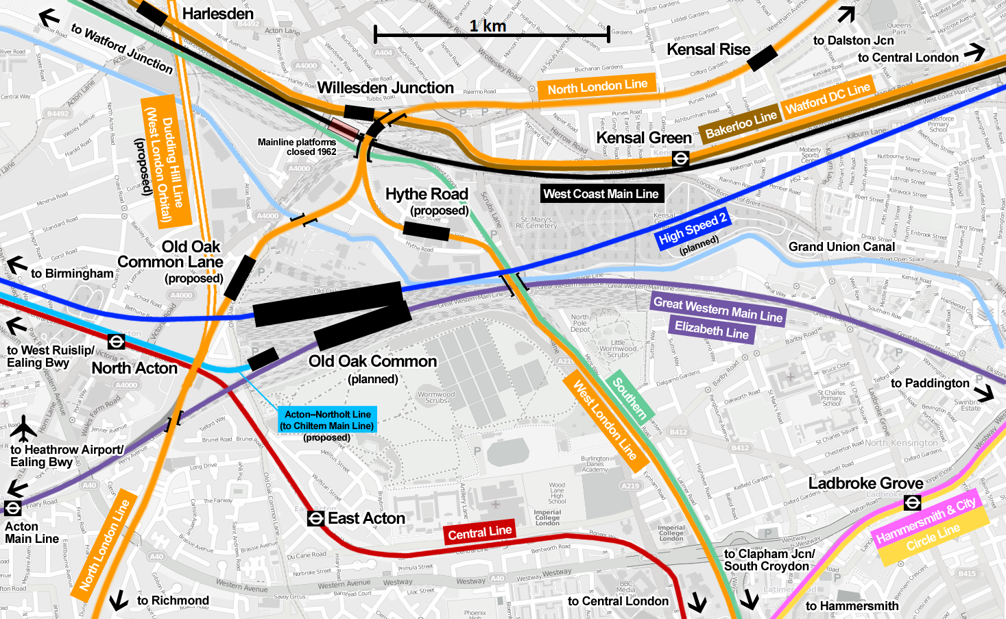 |
| Old Oak Common map from Wikimedia Commons |
Squeezing such a complex interchange onto the Tube map would ordinarily be quite difficult, but a quirk of the Tube map's layout makes this easier. The Tube map has always exaggerated the distance between Willesden Junction and North/East Acton, leaving a gap where Old Oak Common can be stuck in.
The different Overground stations connecting with Old Oak Common have been given different names: Hythe Road on the line to Shepherd's Bush, Old Oak Common Lane on the line to Willesden Junction and Old Oak Common Victoria Road (along the grey Dudding Hill Line on the map above) on the line to Harlesden. Needless to say, fitting all these names on the map would have been a struggle!
What's going on at Ealing Broadway?
This is a quirky one, pointed out to me by the Good People of the Internet™ when I posted a previous version of the map. The biggest issue with the current arrangement is the track shared between the District and Piccadilly lines at Ealing Common; cutting back the District line from Ealing Broadway and sending the Piccadilly line there instead means that both lines can be more frequent and reliable. (London Reconnections has a great article on this which explains it all much better than I can.)What happened to the step-free access icons? What about fare zones?
I omitted both of these because their futures are so hard to predict. Step-free access improvements are made regularly and aren't planned as far in advance as new lines and extensions. Right now we don't know what zones the western Crossrail stations will be in; by 2040 the fare zone system could well have been overhauled in its entirety.
Similarly, it's tough to predict what will have happened to the London Overground by 2040. TfL has its eye on the whole of South London's suburban lines, plus the Northern City Line to Moorgate (see this map from the Transport Strategy), but what happens will have a lot to do with politics (again, London Reconnections has a great in-depth article on this).
Where's [proposed new line/station that's not on the map]?
A lot of people have asked why the Croxley Rail Link, which would re-route the Metropolitan line from Croxley to Watford Junction, isn't on this map. It's appeared on future Tube maps before, including TfL's own 2021 Tube map (published in 2013), but at present it looks a lot less likely to happen; in the Transport Strategy it's not mentioned once. Having "is this proposal in the Transport Strategy?" ended up being a useful criterion for what to show: this way there are no "maybe I should throw this in?" grey areas.What about Thameslink?
When making the map I tried to stay as close as possible to the principles behind the original Tube map; this meant showing the Overground, Tramlink, Emirates Air Line and DLR but not showing rail lines which aren't run by TfL. Many people who saw the map asked whether lines like Thameslink (a train line which runs across London but isn't run by TfL) or new National Rail links around Heathrow Airport ought to be included.
But at the same time others asked whether there was already too much information crammed onto the Tube map, especially when projected forward to 2040. Jonn Elledge at CityMetric asked whether including Overground, the Crossrails and the Tramlinks makes the map too cluttered.
The balance between (on the one hand) providing enough information to usefully assist journey planning and (on the other hand) avoiding information overload is a super tough one. I definitely don't have any easy answers, which is the main reason why, when it came to the criteria for which lines to include on the map, I stuck to the status quo (or at least what was the status quo, until Thameslink joined the official Tube map in 2020).
Mate love it, but Id put Thameslink on esentilly as a CR3 or Overround and also make the Greenford Shuttle part of the Overground. - Tony
ReplyDeleteBTW any chance of the vector to make a poster
I agree with adding the Greenford shuttle as once the Elizabeth Line is up and running it is planned to hand it to the Overground.
ReplyDeleteAlso as you state, by then Camden station will have been rebuilt and TFL plans to split the Northern Line into two seperate lines to save confusion.
I really like your maps but wanted to ask how you make them, ie. which software, etc.
ReplyDeleteThank You in Advance
Hi!
DeleteI use Inkscape to make these maps.
Thank You and Keep up the good work!!
ReplyDelete