The Docklands light Railway (DLR, for short) has been one of London's major transport success stories. Opening with just 15 stations in 1987, the network currently serves 45 stations in East and Central London. Unlike buses, trams, the London Overground or TfL Rail, the DLR yields more for TfL in passenger revenue than it costs to operate. The system played a pivotal role in bringing regeneration to the London Docklands and transforming Canary Wharf into the one of the world's most important financial centres.
In some ways the DLR has been a victim of its own success. With passenger numbers exceeding expectations, many of the past and planned improvements to the DLR have focused on increasing capacity: in particular, by lengthening trains and station platforms and by improving junctions so that services can run more frequently.
But it's also intriguing to look at which new destinations the Docklands Light Railway might serve. The map below depicts the current DLR network, together with a number of extension proposals, past and present:
However, it's worth stressing from the outset that official consideration of DLR extensions has more recently become much narrower. In the Mayor's Transport Strategy from March 2018, discussion of the DLR focuses specifically the proposed extension from Gallions Reach to Thamesmead.
The DLR extensions map contains some annotations which explain a little bit of the background and trivia behind the proposals. Below are descriptions of a couple of the proposals in geekier detail.
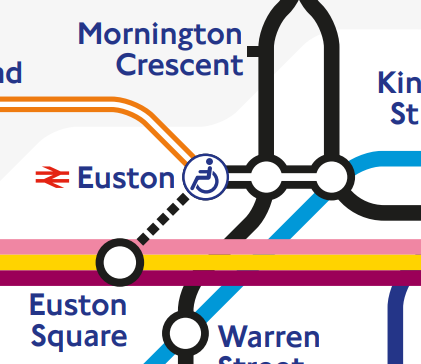
A DLR extension to St Pancras and Victoria (listed as "Option A" on the main map above) would be particularly ambitious. As noted at London Reconnections, the portion from Euston to St Pancras would follow the same route as that proposed for an automated people mover (APM) between Euston and St Pancras. The APM would quicken the connection between HS1 (at St Pancras) and HS2 (at Euston), and a DLR extension would play a very similar role.
Crossrail 2 would also create a connection between Euston and St Pancras with a new station underground. Putting this new station on the Tube map as an interchange with Euston and King's Cross St Pancras is a very tough task, and my own attempt (for the 2040 Tube Map) could definitely be improved upon. Adding DLR stations to Euston and St Pancras, in addition to the Crossrail 2 link, would be an even tougher challenge.
In some ways the DLR has been a victim of its own success. With passenger numbers exceeding expectations, many of the past and planned improvements to the DLR have focused on increasing capacity: in particular, by lengthening trains and station platforms and by improving junctions so that services can run more frequently.
But it's also intriguing to look at which new destinations the Docklands Light Railway might serve. The map below depicts the current DLR network, together with a number of extension proposals, past and present:
 |
| Docklands Light Railway network, with proposed extensions |
Sources and caveats
All of the extensions on the map come from official sources: most come from the DLR Horizon 2020 Study (from July 2005) and the "Planning for the Future of the DLR" map (from May 2011, shown below). |
| Original map can be found archived here, with its accompanying article here |
 |
| Detail from Figure 31 of the Mayor's 2018 Transport Strategy, with DLR extension in turquoise |
Wood Wharf extension
The proposal to extend the DLR to Wood Wharf came about because of a capacity constraint in the original DLR. North of West India Quay, the Bank and Stratford branches met each other at a flat crossing. Trains running north from West India Quay to Stratford had to cross the path of trains running south from Bank to West India Quay, limiting the frequency at which trains could run.
The Horizon 2020 report investigated the possibility of sending Stratford trains along a new track which avoided Canary Wharf (and the difficult crossing) entirely. The new track would meet the existing track south of Wood Wharf at a more efficient junction.
The Wood Wharf proposal had drawbacks. In particular, travellers from Stratford would no longer have direct trains to Poplar (providing interchange opportunities with other DLR routes) or the stations on Canary Wharf.
In 2009, a different solution was put in place. New track was built so that trains from Bank could run directly from Westferry to Canary Wharf and avoid crossing the path of trains to Stratford.
This improves the possible service frequency, but means that trains from Bank can't stop at West India Quay. This unusual arrangement isn't currently depicted on the standard Tube map, but is shown on the DLR map:
With the new track in place, there is much less need for the Wood Wharf extension. There will still be new development at Wood Wharf (with completion currently planned for 2023), but without a new DLR station. |
| Very simplified illustration of track north of West India Quay Grey track was rarely used for passenger service |
 |
| Stations around Canary Wharf, including the proposal for Wood Wharf Base image: Google Earth |
In 2009, a different solution was put in place. New track was built so that trains from Bank could run directly from Westferry to Canary Wharf and avoid crossing the path of trains to Stratford.
 |
| Very simplified diagram of new track layout The new track to Canary Wharf passes underneath the tracks to and from Poplar |
 |
| Detail from current official DLR map |
Western extensions
Tunnelling west of Bank would be extremely expensive, and a lot of attention has been given to cunning re-use of existing infrastructure in order to cut costs. The Horizon 2020 report considers the re-use of the Farringdon City Sidings, built alongside the adjacent London Underground track and once used to carry Thameslink trains from Farringdon to Moorgate.
The plan now is to put the tracks to a different use, as a place to stable London Underground trains overnight. This means the tracks are very unlikely to see use as part of a DLR extension.
The plan now is to put the tracks to a different use, as a place to stable London Underground trains overnight. This means the tracks are very unlikely to see use as part of a DLR extension.
 |
| Detail from a 1999 map of London's rail services (saved at the London Tube Map Archive), showing National Rail services from Farringdon to Moorgate |
 |
| Artist's impression of an APM station at St Pancras, from Arup's report to HS2 |
 |
| A monstrous interchange – but it could be even worse |