This post was last updated on 24 May 2022
Crossrail was originally planned to open in December 2018, with services branded as the Elizabeth line. In summer 2018, TfL announced that the line's opening would be delayed, and passengers would not use the new tunnels and stations until May 2022.
Among those who didn't know about the delay until it was a little too late were WHSmith, whose 2019 diaries were prepared with the Elizabeth line on the Tube map at the back:
Among those who didn't know about the delay until it was a little too late were WHSmith, whose 2019 diaries were prepared with the Elizabeth line on the Tube map at the back:
 |
| "Correct at time of going to print." |
The diaries from WHSmith attracted some media attention, but none of the news stories I saw featured any pictures of the diaries or the Tube maps inside them. So I nipped into Holborn's WHSmith this morning to pick up a copy.
What's different?
Having spent a lot of time sticking Crossrail on unofficial Tube maps, I was very curious about how it would look on the "official" Tube map. We've seen before a "draft version" of the December 2018 map (covered here), which is very similar to this one but has the other Tube lines greyed out.
 |
| Broken interchanges at Paddington and Liverpool Street |
On this map, as well as the draft 2018 map, the Bakerloo line at Paddington has moved beneath the Hammersmith and City line. The Elizabeth line is broken up into three sections (with connections at Paddington and Liverpool Street) rather than being shown as one continuous line.
The broken interchanges reflect what was intended to be the service pattern in December 2018: trains from Heathrow and Shenfield would stop at the main line stations at Paddington and Liverpool Street, and you would have to change trains in order to travel on the "core" section between Paddington and Abbey Wood.
The Elizabeth line did not officially appear on the Tube map until the May 2022 version, which had evolved from these earlier drafts. Most significantly, the Bakerloo line is positioned below the Hammersmith and City line at Paddington, while Liverpool Street gets only one station label.
 |
| Paddington and Liverpool Street on the May 2022 Tube map |
Will the Tube map look like this when the Elizabeth line does open?
The style of the Tube map has evolved since the delay to the opening of the Elizabeth line was announced. In particular, there are now dotted lines which mark convenient street-level interchanges between stations. When the Elizabeth line does open, we're likely to see a new dotted line joining Woolwich with Woolwich Arsenal.
In addition, the pocket Tube map, online map and station platform maps will almost certainly continue to mark fare zones and step-free access.
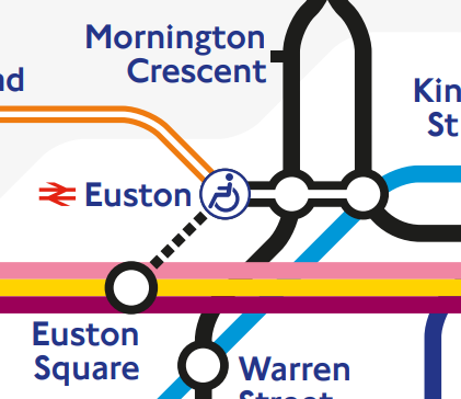 |
| Step-free access icons, zone boundaries and dotted interchange lines |
Services between Reading and Paddington, which aren't shown on the WHSmith map, had been planned due to join the Elizabeth line in December 2019. In part because these services are very profitable to run, they were incorporated into TfL Rail before the core section of the Elizabeth line opened.
This means that the WHSmith Tube map (which shows the core section but not Reading services) is particularly peculiar. Rather than simply a Tube map of the future, has ended up being a map which never exactly matched reality.
No comments:
Post a Comment
Note: only a member of this blog may post a comment.